Hiking Mt Yotei (Yoteizan)
It's been a while since I posted...nevertheless, better late than never!
So last weekend I spent a few days in Kutchan, Hokkaido, Japan. It's a beautiful region of the north of Japan, and the autumn colours were amazing. On this trip to Hokkaido I was keen to smash out some hiking, but after looking into the various options, the Kutchan/Niseko region seemed to be my best bet, to avoid the snow which is already starting to accumulate on the tops of mountains further north. That, and the bears that are on their final food gathering runs, which are routinely spotted in the national parks in the central/northern parts of Hokkaido!
Being without an international drivers license, public transport was my only option (short of hitchiking). I was using Sapporo as my first port of call, so I booked some accomodation in Kutchan using Airbnb and then caught the train to Kutchan. This was simple enough, with one change required at Otaru, to switch to the local Kutchan train.
The climb itself was a little bit of a mission, especially as the first time I attempted it (on the Saturday), the forecast was for prolonged rain. I checked the weather in the morning, and as it wasn't raining early on, I took a bit of a gamble and decided to go anyway. There are four different trails to get to the peak, I decided on the Kutchan (also known as the Hirafu) trail head. To get to the trailhead, I took a Donan bus which leaves from just to the left of the Kutchan train station (if you are looking at the station). Note that the buses don't run that frequently - so it's important to check the times. There is an information desk in the station that is open from 9am to 5pm that can help you with the timetables. The Niseko Bus company also runs services past the trailhead. The google location of the trailhead is here.
Note that the timetable above is for summer (2019) only. The top line is the departure time from Kutchan station. The third line is the approximate arrival time at the bus stop closest to the trailhead on Route 5, while the red underlined row is the return times from the Yoteizan-tozan-guchi bus stop. Note that note all services run on Sunday - for example the 6:40 first bus doesn't run - so check with the info office in the JR station or the Donan office (just outside the station) if you can.
The trailhead is about a ten minute cruise down route 5, the stop to get off at is Yoteizan-tozanguchi (tozan means mountain climbing in Japanese, while guchi means entrance). The bus drops you off about 50 metres past a narrow road that leads to the hiking parking lot, and Lake Hangetsu campgrounds. It's about a 20-25 minute walk from the bus stop to the start of the trail - you have to take a slight right at the Lake Hangetsu parking lot to get to the trailhead.
The hike itself is great. It is divided into ten stations. It's important to note that there is no food or drinks available for purchase in the park - so you have to carry what you need for the whole day with you. It's also quite a difficult trail - super steep, with plenty of scrambling required, ducking under tree branches, and the occasional climbing over and up tree roots and boulders. I wouldn't recommend you do this unless you are in decent condition, and mobile. From the blogs I've read, most people allow around 3.5 hours to get up and about 3 to get down. You can also do a circuit of the top which will take 30-60 minutes as well. It took me 6.5 hours to get up the trail and back, although I did spend a fair while stopped at the top for lunch and taking photo's. I also wanted to catch a bus home at 14:14 and get back to Sapporo from Kutchan in the afternoon, so ended up jogging down a bit of the path down. I wouldn't really advise this though given the rocky/slippery conditions, unless you really need to.
The other big things for me were the weather conditions, footwear and poles. The first day while it was raining, I got to the 9th station. The conditions were pretty miserable though, with sleeting rain, and gusty winds. So I took a right at the 9th station and sort refuge at the Mt Yotei hut. A dude I met on the trail had just come back from the summit, and reported 50km an hour winds, so I decided to head back down and give it another go the next day (Sunday). The rain had made the trail quite muddy and slippery, so decent boots with grip would be highly recommended. A lot of the trail is quite rocky as well, so stiff rubber soles would be advantageous. The other key for me was my 'hiking pole' - in lieu of proper poles, I used a 70 yen umbrella, and I have to say it saved me a few times from slipping over and also gave me much more balance on the way down.


The top itself is great - if it's a clear day. You can see views of the valley's below, and also of the caldera. Note that getting around the entire crater is pretty difficult - a lot of scrambling required, it's not an easy trail. They've used white paint to mark the trail, which was an interesting choice, given the amount of snow Hokkaido gets, and the white moss that is growing all over most of the rocks, but, hey, I'm not the boss of the mountain, so just roll with it.


Definitely a worthwhile hike. I have to say though that it is very weather dependent. Allowing a window of a couple of days to do this really worked for me - it would have been disappointing if I only had the Saturday to try and hike it while it was raining.
It turns out that the 14:14 Niseko bus back to town that I was trying to catch doesn't run on Sundays (dammit!), so instead of waiting 90 minutes by the side of the road for the 15:56 Donan bus, I headed back down the road to check out Lake Hangetsu. Thank goodness I missed the bus, because the colours and the views were amazing!


Very grateful that the 14:14 bus doesn't run on weekends! If you can afford the time, Lake Hangetsu is definitely worth a look. All in all it was a great day's hike. Would definitely recommend if you are in the area, and the weather is good. Check the weather, check the bus schedule, check your shoes, grab a pole (or an umbrella!) and get up there!
Thanks to these bloggers whose references I found useful:
So last weekend I spent a few days in Kutchan, Hokkaido, Japan. It's a beautiful region of the north of Japan, and the autumn colours were amazing. On this trip to Hokkaido I was keen to smash out some hiking, but after looking into the various options, the Kutchan/Niseko region seemed to be my best bet, to avoid the snow which is already starting to accumulate on the tops of mountains further north. That, and the bears that are on their final food gathering runs, which are routinely spotted in the national parks in the central/northern parts of Hokkaido!
 |
| Mt Yotei, taken from just west of Kutchan |
Being without an international drivers license, public transport was my only option (short of hitchiking). I was using Sapporo as my first port of call, so I booked some accomodation in Kutchan using Airbnb and then caught the train to Kutchan. This was simple enough, with one change required at Otaru, to switch to the local Kutchan train.
The climb itself was a little bit of a mission, especially as the first time I attempted it (on the Saturday), the forecast was for prolonged rain. I checked the weather in the morning, and as it wasn't raining early on, I took a bit of a gamble and decided to go anyway. There are four different trails to get to the peak, I decided on the Kutchan (also known as the Hirafu) trail head. To get to the trailhead, I took a Donan bus which leaves from just to the left of the Kutchan train station (if you are looking at the station). Note that the buses don't run that frequently - so it's important to check the times. There is an information desk in the station that is open from 9am to 5pm that can help you with the timetables. The Niseko Bus company also runs services past the trailhead. The google location of the trailhead is here.
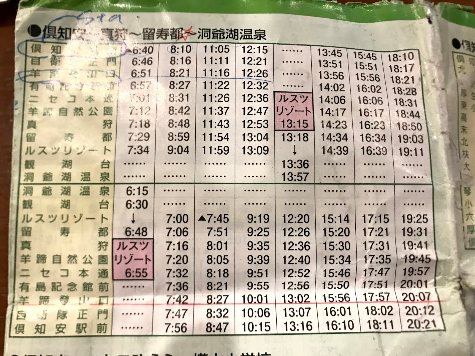 |
| Donan Bus timetable from Kutchan Station to the Lake Hangetsu Trailhead |
Note that the timetable above is for summer (2019) only. The top line is the departure time from Kutchan station. The third line is the approximate arrival time at the bus stop closest to the trailhead on Route 5, while the red underlined row is the return times from the Yoteizan-tozan-guchi bus stop. Note that note all services run on Sunday - for example the 6:40 first bus doesn't run - so check with the info office in the JR station or the Donan office (just outside the station) if you can.
The trailhead is about a ten minute cruise down route 5, the stop to get off at is Yoteizan-tozanguchi (tozan means mountain climbing in Japanese, while guchi means entrance). The bus drops you off about 50 metres past a narrow road that leads to the hiking parking lot, and Lake Hangetsu campgrounds. It's about a 20-25 minute walk from the bus stop to the start of the trail - you have to take a slight right at the Lake Hangetsu parking lot to get to the trailhead.
 |
| The sign to the trailhead entrance from Route 5 |
 |
| The map at the Lake Hangetsu parking lot. Proceed straight/slight right for the Mt Yotei hike, left for Lake Hangetsu |
 |
| Trailhead start |
The hike itself is great. It is divided into ten stations. It's important to note that there is no food or drinks available for purchase in the park - so you have to carry what you need for the whole day with you. It's also quite a difficult trail - super steep, with plenty of scrambling required, ducking under tree branches, and the occasional climbing over and up tree roots and boulders. I wouldn't recommend you do this unless you are in decent condition, and mobile. From the blogs I've read, most people allow around 3.5 hours to get up and about 3 to get down. You can also do a circuit of the top which will take 30-60 minutes as well. It took me 6.5 hours to get up the trail and back, although I did spend a fair while stopped at the top for lunch and taking photo's. I also wanted to catch a bus home at 14:14 and get back to Sapporo from Kutchan in the afternoon, so ended up jogging down a bit of the path down. I wouldn't really advise this though given the rocky/slippery conditions, unless you really need to.
The other big things for me were the weather conditions, footwear and poles. The first day while it was raining, I got to the 9th station. The conditions were pretty miserable though, with sleeting rain, and gusty winds. So I took a right at the 9th station and sort refuge at the Mt Yotei hut. A dude I met on the trail had just come back from the summit, and reported 50km an hour winds, so I decided to head back down and give it another go the next day (Sunday). The rain had made the trail quite muddy and slippery, so decent boots with grip would be highly recommended. A lot of the trail is quite rocky as well, so stiff rubber soles would be advantageous. The other key for me was my 'hiking pole' - in lieu of proper poles, I used a 70 yen umbrella, and I have to say it saved me a few times from slipping over and also gave me much more balance on the way down.

 |
| Met this guy on the way up |


 |
| Top of the Kutchan trail. Left points to the summit, while the sign going back is to the bottom. Note that in Japanese it says 'Hirafu descent'. Something to look out for if you circle the caldera. |
 |
| View from the top of the Kutchan trail |
The top itself is great - if it's a clear day. You can see views of the valley's below, and also of the caldera. Note that getting around the entire crater is pretty difficult - a lot of scrambling required, it's not an easy trail. They've used white paint to mark the trail, which was an interesting choice, given the amount of snow Hokkaido gets, and the white moss that is growing all over most of the rocks, but, hey, I'm not the boss of the mountain, so just roll with it.
 |
| Summit! |
 |
| View of the caldera. No snow on the top, due to rain and sunshine the days before |
 |
| View of Kutchan and Niseko, on the way down |


 |
| Done! |
Definitely a worthwhile hike. I have to say though that it is very weather dependent. Allowing a window of a couple of days to do this really worked for me - it would have been disappointing if I only had the Saturday to try and hike it while it was raining.
It turns out that the 14:14 Niseko bus back to town that I was trying to catch doesn't run on Sundays (dammit!), so instead of waiting 90 minutes by the side of the road for the 15:56 Donan bus, I headed back down the road to check out Lake Hangetsu. Thank goodness I missed the bus, because the colours and the views were amazing!
 |
| Mt Yotei from the road to Yoteizan-Tozan-Guchi |
 |
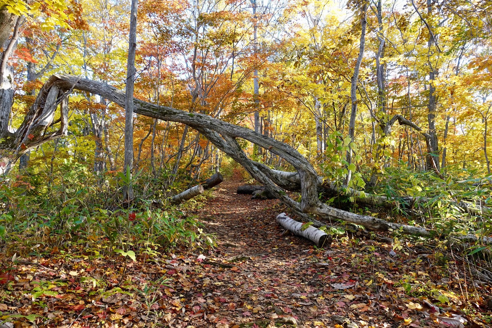
| Lake Hangetsu. Autumn colours are amazing! |


Very grateful that the 14:14 bus doesn't run on weekends! If you can afford the time, Lake Hangetsu is definitely worth a look. All in all it was a great day's hike. Would definitely recommend if you are in the area, and the weather is good. Check the weather, check the bus schedule, check your shoes, grab a pole (or an umbrella!) and get up there!
Thanks to these bloggers whose references I found useful:
- https://www.japanhoppers.com/en/hokkaido/niseko/kanko/499/
- https://en.japantravel.com/hokkaido/climbing-mt-yotei/6169
Sidesnotes: During my time in Kutchan I went to Harvest Cafe and also Sekka Lab Dining and Bar. Both are about 5 minutes walk from the station. Harvest Cafe is a cosy little joint that does an excellently presented and tasty chicken karaage, amongst other things, and is a good spot to hang out and kill some time. Sekka Lab is a bit of a fusion/fine dining experience, in an incredible space and is a fantastic option for dinner.
penned by Maxi at
10:07 PM
|
0 comments
![]()
